It is the traditional capital of a hima (Khasi tribal chieftainship constituting a petty state) known as Sohra or Churra.
The original name for this town was Sohra, which was pronounced "Churra" by the British. This name eventually evolved into the current name, Cherrapunji. The name "cherrapunji" which means 'land of oranges' was first used by tourists from other parts of India. Despite perennial rainfall, Cherrapunji faces an acute water shortage and the inhabitants often have to trek for miles to obtain potable water. Irrigation is also hampered due to excessive rain washing away the topsoil as a result of human encroachment into the forests. The Meghalaya state government has renamed Cherrapunjee back to its original name, "Sohra". There is a monument to David Scott (British Administrator in NE India, 1802 in the Cherrapunji cemetery. The history of the Khasis the inhabitants of Cherrapunji may be traced from the early part of the 16th century. Between the 16th and 18th centuries these people were ruled by the 'Syiems (rajas or chiefs) of Khyriem' in the Khasi hills. The Khasi hills came under British authority in 1883 with the submission of the last of the important syiems, Tirot Singh.
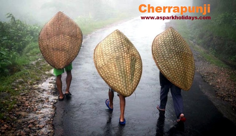
History Of Cherrapunji- As in days gone by, the faces of Cherrapunji change not with the seasons, but with the pattern of rainfall. The heaviest downpours span approximately five long months-from May until September. The clouds then are dark and menacing, full blown with rain, which descends earthwards with the stinging force of a whiplash.
Throughout these months, Cherrapunji is transformed into a sea of tiny, gushing rivulets. The raindrops beat incessantly on rooftops and treetops creating a compelling tattoo of awesome sounds, which cannot be savored anywhere else but in the Northeastern states. These are also the 'record-making' months, which contribute to records such as the stunning 22,987 mm of rainfall in 1861. The annual average rainfall of Cherrapunji stands today at 10,871 millimetres. Barely 10 km from Cherrapunji stands the village of Mawsynram, which has snatched away the heaviest rainfall record, with 12,163 millimetres of rainfall.
With the passage of September, the rhythm of the rain-its main force spent-changes to a gentle patter. And the Khasis and other residents of Cherrapunji, the flora, and the fauna respond to the change in the Rain God's mood. Soft pastel shades begin to appear in skies that were gray all day and rainbows that are a photographer's delight begin to make unexpected guest appearances.
Must visit Spots in Cherrapunji
Living Root Bridge- Meghalaya's double-decker and single-decker root bridges are unique in the world and are a sight to behold. The bridges are tangles of massive thick roots, which have been intermingled to form a bridge that can hold several people at a time. Khasi people have been trained to grow these bridges across the raised banks of streams to form a solid bridge, made from roots. The living bridges are made from the roots of the Ficus elastics tree, which produces a series of secondary roots that are perched atop huge boulders along the streams or the riverbanks to form bridges. The root bridges, some of which are over a hundred feet long, take ten to fifteen years to become fully functional, but they are extraordinarily strong strong enough that some of them can support the weight of fifty or more people at a time. The bridges are alive and still growing and gain strength over time.
Mawsmai Caves- Mawsmai caves, a few miles further away from Cherrapunji is fast emerging as a new tourist destination. The caves, made of limestone, spellbind the visitor the moment he enters the caverns. The entrance is well lit, but as one enters further inside, the eerie ness and the mystery, starts unfolding. Coupled with that, the constant dripping of water from the cave roofs and the formation of stalactites and stalagmites, a phenomena specially found in limestone caves, where the roof and the floor of the cave joins together to form pillars, adds to the beauty of the place. While at some places, the openings are big enough for a person to just about crawl through, at others, the roofs as high as 40 feet! Interestingly, while the entrance is large and roomy, the exit is so small, that a full-grown person has to kneel down for coming out into the open.
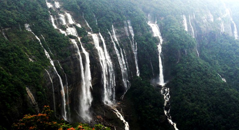
Nohkalikai Falls- Nohkalikai Falls is the tallest plunge waterfall in India. Its height is 1115 feet (340 metres). The waterfall is located near Cherrapunji, one of the wettest places on Earth. Nohkalikai Falls are fed by the rainwater collected on the summit of comparatively small plateau and decrease in power during the dry season in December - February. Below the falls there has formed a plunge pool with unusual green colored water.
The name of the falls in Khasi language meaning "Jump of Ka Likai" is linked to a legend about local women Likai who jumped off the cliff next to the falls.
Tourists Attractions Of Cherrapunji:- The home of enterprising Khasi clans, Cherrapunji's place in the Guinness Book of Records is not its only claim to fame. Along with falls lesser in height but no less alluring, the spectacular, cascading 1,035-ft-high Mawsmai Falls-the fourth highest in India-lie just a few kilometres beyond Cherrapunji.
Close by is situated a fascinating labyrinth of underground passages beneath age-old caves-a veritable dream for amateur explorers. Elsewhere around Cherrapunji, Khasi monoliths (stones in memory of their ancestors) lie dotted around-a vague reminder of the forests of Bastar.
Amidst all the surprises of Cherrapunji, perhaps the most abiding is the startling realization that the wettest place on earth where it rains every month also has an amazing amount of warm sunshine. When the clouds drift away, there are a series of memorable views, and one can see as far as Bangladesh. Orchids blooming a few feet away form a patch devoid of vegetation. Dense woods interspersed by rocky, cliffs furrowed by erosion.
As the months move on, the smell of decaying vegetation lessens as the showers become intermittent. New plants spring to life, and people go about their tasks with renewed energy.
The hills around Cherrapunji do not have the lush green vegetation one normally associates with wet places. The vegetative cover in the form of dense woods appears in patches and constitute yet another marvelous surprise: the richness and variety of the flora in these 'zones' has to be seen to be believed. An amazing variety of rare orchids, ferns, and moss convert each pocket into a botanist's paradise. Cherrapunji produces the best quality of oranges as well as pineapples. In fact, Cherrapunji oranges are the ancestors of the famous Nagpuri oranges in the Central India.
How To Reach Cherrapunji- Cherrapunji is 58 km from Shillong, the capital of Meghalaya. A steep motorable road, almost perpetually bathed in mist as it climbs upwards on the last lap, leads up to Cherrapunji. Buses and taxis ply to Cherrapunji from Shillong.
Aspark Holidays provides complete information on Cherrapunji, about tourism in Cherrapunji. Aspark Holidays offers various tour packages to make you visit comfortable. You can pick the one that suits you most.
Need Aspark Help?
For Tour Packages, Vehicle Rental and Customer Care Support.
+91 9999 31 7846
booking@asparkholidays.comWhy Travel with Us?

Excellent Support
Our Team Available 24x7 for Customer support
Best Price & Savings
We Offer the Most Competitive Prices.


